 EMODnet Product Catalogue
Fiskeridirektoratet - Norway
Type of resources
Available actions
Topics
Keywords
Contact for the resource
Provided by
Years
Formats
Representation types
Scale 1:
-
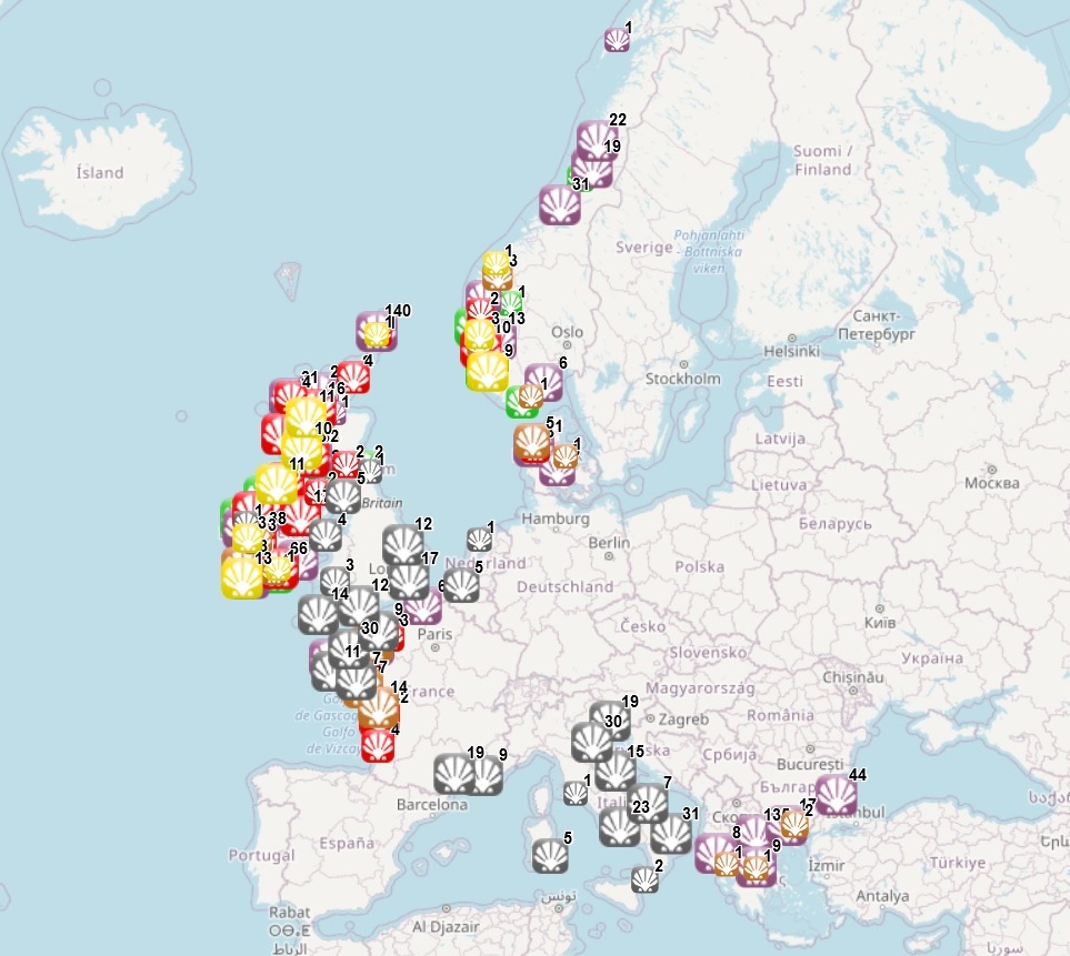
The dataset on shellfish aquaculture in the Eropean seas was created in 2014 by AND-International for the European Marine Observation and Data Network (EMODnet). It is the result of the aggregation and harmonization of datasets provided by national sources across the EU (plus Norway and the UK) and by the project Euroshell. The dataset contains points representing shellfish farms or shellfish production areas (depending on available data) in the following countries: Bulgaria, Denmark, France, Greece, Ireland, Italy, Netherlands, Norway, Slovenia, Spain and United Kingdom. Data from Bulgaria, Denmark, Greece, Ireland, Norway, Spain and Scotland come from the official lists of registered aquaculture sites. Data from France relies on cadastral data. Data from the Netherlands, Italy and England and Wales come from the Euroshell project. Data is missing for Germany, Portugal, Sweden and Croatia. Except for Germany, the shellfish production remains limited in those MS. There is no production in other MS. Each point has the following attributes (where available): status (active, inactive, licensed), country, owner name, farm type (Mussels, Oysters, Mussels-Oysters, Clams, Specialised (other), Mixed (other)), production method (Beds, Long lines, Rafts, Saltwater closed (recirculation), Saltwater ponds, Saltwater tanks/raceways, Trestles or trays, Other), production stage (Grow out for human consumption, Hatchery, Nursery, Broodstock, Reproduction, Harvest, Other), purpose (Commercial, Research, Education, Display, Other), products detailed (English translation of the information provided on species grown or authorised in the source), point information (Polygon centroid, Original) depending on how the information is provided in the source (polygons or points), site_id, distance to coast (metres), position from coastline (At sea, within the coastline). The farm type relies on a typology established by AND-International, based on available information on species grown or authorised. A relational table provides harmonised information about species grown or authorised using Eurostat nomenclature for the Species Group (Mussels; Oysters; Clams, cockles, arkshells; Scallops, pectens; Abalones, winkles, conchs; Sea-urchins and other echinoderms) and when available the species name (e.g. Blue mussels - Mytilus edulis). The distance to coast (EEA coastline shapefile) has been calculated using the original data map projections, where available. In the other cases it was used the UTM WGS84 Zone projected coordinate system where data fall in. Compared with the previous version this new version includes updated data for Denmark, Greece, Ireland, Norway and Scotland and new data from Slovenia and Spain. Data are available for viewing and download on EMODnet - Human Activities web portal (https://emodnet.ec.europa.eu/en/human-activities), except for the data from Spain, which are available in the viewer, but not for download.